


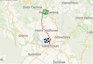

5.5 km | 7.3 km-effort
![Trail On foot Horní Čermná - [M] Lanškroun - Mariánská hora - Photo](https://media.geolcdn.com/t/1900/400/8b0f16b7-adca-43fb-abe5-f09d20153e0a.jpeg&format=pjpeg&maxdim=2)

Tous les sentiers balisés d’Europe GUIDE+


FREE GPS app for hiking
 SityTrail
IGN / Geographical institutes
SityTrail World
The world is yours!
Trail On foot of 7.1 km to be discovered at Northeast, Pardubický kraj, Horní Čermná. This trail is proposed by SityTrail - itinéraires balisés pédestres.
Trail created by cz:KČT.
![Trail On foot Horní Čermná - [M] Lanškroun - Mariánská hora - Photo 1](https://media.geolcdn.com/t/2048/auto/be76bb8e-2270-44b0-874e-7687284a5921.jpeg&format=jpg&maxdim=0 "Trail On foot Horní Čermná - [M] Lanškroun - Mariánská hora - Photo 1")
![Trail On foot Horní Čermná - [M] Lanškroun - Mariánská hora - Photo 2](https://media.geolcdn.com/t/2048/auto/44a0ee81-2835-4fe0-850c-e8d9f417090a.jpeg&format=jpg&maxdim=0 "Trail On foot Horní Čermná - [M] Lanškroun - Mariánská hora - Photo 2")
![Trail On foot Horní Čermná - [M] Lanškroun - Mariánská hora - Photo 3](https://media.geolcdn.com/t/2048/auto/105b962c-c051-4078-afd9-acf5da639c98.jpeg&format=jpg&maxdim=0 "Trail On foot Horní Čermná - [M] Lanškroun - Mariánská hora - Photo 3")
![Trail On foot Horní Čermná - [M] Lanškroun - Mariánská hora - Photo 4](https://media.geolcdn.com/t/2048/auto/bfb304e0-fd66-4861-91a9-e01ff29b993e.jpeg&format=jpg&maxdim=0 "Trail On foot Horní Čermná - [M] Lanškroun - Mariánská hora - Photo 4")
![Trail On foot Horní Čermná - [M] Lanškroun - Mariánská hora - Photo 5](https://media.geolcdn.com/t/2048/auto/5ab3eed2-eb21-43ea-a19d-8955207b343b.jpeg&format=jpg&maxdim=0 "Trail On foot Horní Čermná - [M] Lanškroun - Mariánská hora - Photo 5")
![Trail On foot Horní Čermná - [M] Lanškroun - Mariánská hora - Photo 6](https://media.geolcdn.com/t/2048/auto/725f0a66-34fa-4f87-92de-c6a329d12a26.jpeg&format=jpg&maxdim=0 "Trail On foot Horní Čermná - [M] Lanškroun - Mariánská hora - Photo 6")
![Trail On foot Horní Čermná - [M] Lanškroun - Mariánská hora - Photo 7](https://media.geolcdn.com/t/2048/auto/05990eeb-52d9-4d41-af39-165c3a5838ca.jpeg&format=jpg&maxdim=0 "Trail On foot Horní Čermná - [M] Lanškroun - Mariánská hora - Photo 7")
![Trail On foot Horní Čermná - [M] Lanškroun - Mariánská hora - Photo 8](https://media.geolcdn.com/t/2048/auto/8b0f16b7-adca-43fb-abe5-f09d20153e0a.jpeg&format=jpg&maxdim=0 "Trail On foot Horní Čermná - [M] Lanškroun - Mariánská hora - Photo 8")
![Trail On foot Horní Čermná - [M] Lanškroun - Mariánská hora - Photo 9](https://media.geolcdn.com/t/2048/auto/a4e7bade-d295-41c0-b2c0-92a57a687578.jpeg&format=jpg&maxdim=0 "Trail On foot Horní Čermná - [M] Lanškroun - Mariánská hora - Photo 9")
![Trail On foot Horní Čermná - [M] Lanškroun - Mariánská hora - Photo 10](https://media.geolcdn.com/t/2048/auto/86e9883a-5620-4b3e-9a1f-4143d0ad51e0.jpeg&format=jpg&maxdim=0 "Trail On foot Horní Čermná - [M] Lanškroun - Mariánská hora - Photo 10")
On foot